For a writing project I’m working on, I need to explain why the city of Dan was located at the far northern end of Israel when their tribal allotment was 100 miles to the south, on the Mediterranean coast to the west of Jerusalem. The problem for the Danites was, of course, that their tribal allotment was occupied by the Philistines, a fiercely war-like people who enjoyed two technological advantages over the Israelites: chariots and iron weapons. Add to that the fact that most of their tribal allotment was along the coastal plain where Philistine chariots were particularly effective, and you can immediately see the challenge the Danites were facing.
I also want to integrate the life of Samson into my explanation. Samson was a Danite whose exploits all took place in the Sorek valley. I therefore need to know where the Sorek valley is in relation to Dan’s tribal allotment, the northern city of Dan, and the territory of the Philistines.
If I had to rely on a Bible program which uses pre-drawn maps, I would be out of luck here. I would certainly be able to find a map of the tribal allotments of Israel, and that map might even show the territory of the Philistines, but good luck finding the valley of Sorek on such a map. I might then be able to find another map which is focused on the life of Samson and the Sorek valley, but chances are that map would not show me the boundaries of Dan’s allotted inheritance.
I would run into the same problem with even the best Bible Atlases in print. No print Atlas can create a map to answer every potential question about biblical geography. So they all give you certain standard maps, and the best ones will offer a few more detailed or specialized maps. Still, if the question you have is not one the makers of the atlas anticipated, you’re left to try and piece together an answer from multiple maps that don’t quite address your question.
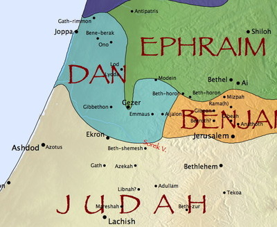
The beauty of the Accordance Bible Atlas is that it’s completely interactive and customizable, so you can actually make the map that will give you the information you need. Rather than giving you separate static maps, it gives you a wide variety of site, region, and route layers which can be combined however you like. In addition to choosing a combination of layers, you can also search for any site or region, and it will show up on the map even if it’s not part of the current layer you have displayed. For example, here I’ve chosen the Tribes of Israel region layer and searched for the Sorek valley:
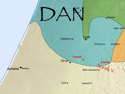
From this I can see that the Sorek valley begins in the foothills at the border of Dan’s allotted territory and eventually opens out onto the coastal plain. If I were to search for a few sites mentioned in connection with Samson, such as his hometown of Zorah or the Philistine town of Timnah, I can see just how far the Danites had gotten in the conquest of their allotted territory.
As you can see, Israelite Zorah was deep in the foothills, while Philistine Timnah was near the edge of the coastal plain. That tells me that the Danites of Samson’s day were largely bottled up in the foothills where Philistine chariots were less effective. It would seem they hadn’t been very successful driving the Philistines out of the coastal plain.
My map already tells me a lot about the situation the Danites faced, but I have yet to place the Philistines on it. I could search for Philistia, but that would only put the label on the map. Since I really want the borders to appear, I need to choose a region layer that includes Philistia, such as Divided Kingdoms or Israel’s Neighbors. There’s just one problem: I already have the Tribes of Israel region layer displayed. How can I add two layers of the same type to my map?
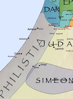
It actually couldn’t be simpler. If you hold down the shift key while selecting another layer, Accordance will add that layer to the one currently displayed. So if I shift-select Israel’s Neighbors, I get this:
By combining multiple layers like this, I can see just how much of Dan’s tribal allotment remained dominated by the Philistines. In view of this inability to dislodge the Philistines, the Danites began looking for some unclaimed territory which would be easier to conquer, and they eventually settled on the northern city of Laish, which they conquered and renamed Dan.
Not only has the flexibility of the Accordance Atlas given me the ability to research this messy territorial dispute, but if I need to explain it to someone else, I need only show them this map I’ve created. Pretty cool, huh?


