Yesterday in my Sunday School class, I was teaching on Genesis 22, the story of Abraham’s binding of Isaac. One of the elements of that narrative is the description of their journey to the land of Moriah.
It is clear from the surrounding context that Abraham and Isaac began their journey at Beer-sheba, and the narrative records that “on the third day” Abraham saw their destination in the distance. Since 2 Chronicles 3:1 identifies the temple mount in Jerusalem as “Mount Moriah,” it appears that Jerusalem was their intended destination. If that was really the case that they were traveling from Beersheba to Jerusalem, would Abraham really have seen Mount Moriah at a distance “on the third day”?
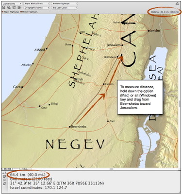
The Accordance Bible Atlas makes it easy to measure distances from one point to another: simply hold down the option key (on Mac) or alt key (on Windows), then click and drag from one point to another. The distance will be calculated and displayed in the top right corner of the map window as well as in the Instant Details. As long as you keep holding down the option/alt key, you can even click and then drag in a different direction.
Using 20 miles as the average distance they could have walked per day, I dragged until I reached 20 miles, which put them a little south of Hebron. Twenty miles more placed them just north of Bethlehem, and Jerusalem was only 4 or 5 miles beyond that. Thus, Abraham would indeed have seen Mount Moriah at a distance at some point on their third day of traveling.
Have you used this feature of the Accordance Atlas yet? Share any interesting discoveries you’ve made about biblical distances in the comments on this post.


